
Terrain
The area is made up of a small area of superb natural forest and scrub, and an extensive area of new native planting. The area is partly managed by the Woodland Trust and partly by a community trust. There is a good network of small paths, ponds, hills and site of historical and nature interest.
Strictly NO DOGS due to presence of livestock (Sheep)
Map
Map Scale 1:7500
Safety & Future Access
There are a number of areas marked Out of Bounds on the map. These must be strictly adhered to for safety (Deep Marshes / Livestock) and also to ensure our future access to this area.
- The OOB marsh to the west of the map will not be marked on the ground – stay out!
- The OOB marsh and adjacent environmental restricted area on the east will be marked with tape – this must not be crossed.
- The OOB field in the centre of the map contains semi-feral livestock – the fence must not be crossed.
Control stakes will have a small piece of reflective tape towards the top, and the one major crossing point (NOT compulsory, but highly recommended to use) will also have reflective tape for the Night event, and red/white tape for the Score event.
All Score Orienteers will be checked for carrying a whistle, and weather depending, a Cagoule
3-blasts from the whistle is an Internationally Recognized Distress Signal
Tree Disease
Competitors will be required to use a foot bath/spray after leaving the forest to reduce the chance of spreading tree disease.
Mass Start
Registration from 1300 HRS.
Race / Safety Briefing at 1350 HRS at Start location
Mass Start at 1400 HRS Sharp (timed not punched)! Please arrive in good time so you don’t miss this.
Ensure you have a watch set to the correct time or suitable stopwatch. Avoid those plenty points!
Classes
All competitors will use the same map and have the same time (45 minutes) to visit the controls. There will be a penalty of 50 points per minute for late returning runners.
| Junior Men (M16-) | Junior Women (W16-) |
| Open Men | Open Women |
| Veteran Men (M45+) | Veteran Women (W45+) |
| Super Veteran Men (M55+) | Super Veteran Women (W55+) |
Pricing (for Score and Night)
| NIOA Members | Score only | Night Only | Combined |
| Senior | £8 | £8 | £12 |
| Student/Unwaged | £6 | £6 | £9 |
| Junior | £4 | £4 | £6 |
| NIOA Non- Members | Score only | Night Only | Combined |
| Senior | £10 | £10 | £14 |
| Student/Unwaged | £8 | £8 | £11 |
| Junior | £5 | £5 | £7 |
Book a Score Championship Map
Error: Contact form not found.
To book a map for the NIOA Night championships – please use the form on the Night Championship event page.
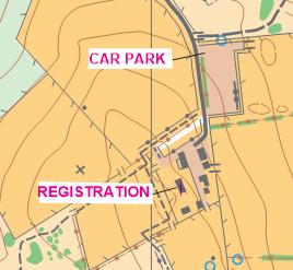
Facilities
Car Parking convenient to Registration, Starts and Finish
Toilet facility available
The Juniors Fundraising Kitchen will be at the event.
Warm-up available along entrance lane – beware of traffic!
NIOA Prize-giving
NIOA Prize-giving in same Barn as Registration
Limited number of chairs, please bring your own folding chairs if possible
Detailed Travel Directions

SAT NAV Info
15 Halfgayne Road
Maghera
BT46 5PB
N 54°52.591′ W 006°41.788′
From Dungiven
19 minutes from Dungiven
Leaving Dungiven on A6 Glenshane Road towards Maghera, approximately 2 miles after the Ponderosa Restaurant, turn left onto Ranaghan Road. Follow this road for 1.7 miles then turn left onto Urbalshinney Road. After 0.8 miles travel over the crossroads to Halfgayne Road, after 0.7 miles entrance to Drumnaph is on the right, travel up this lane, car parking is on the left after 0.2 miles
Google Maps Full Route from Dungiven Link
From Coleraine
36 Minutes from Drumcroone Roundabout
Follow A29 Drumcroone Road towards Maghera, after travelling through Swatragh continue on the A29 for 2.3 miles, turn right onto Gortinure Road, Drumnaph will be signposted with a Brown Signpost at this location. Travel for 1.5 miles and then turn left at the T-Junction with Halfgayne Road and after 0.5 miles entrance to Drumnaph is on the right, travel up this lane, car parking is on the left after 0.2 miles
Google Maps Full Route from Coleraine Link
From Castledawson Roundabout
52 minutes from York Street/M2
Travel North from Castledawson Roundabout on the A6 Glenshane Road for 5.8 miles then turn right onto Mullagh Road, signposted for Maghera and Coleraine. Continue for 0.4 miles to a mini roundabout, turn left following signs to Maghera, follow A42 Main Street straight at the next mini roundabout, through a set of traffic lights, and continue along the Tirkane Road. Drive for 2.1 miles, then turn right onto Halfgayne Road, and after 0.7 miles entrance to Drumnaph is on the right, travel up this lane, car parking is on the left after 0.2 miles
Google Maps Full Route from Castledawson Roundabout Link